
Capture More Than the Scan: Expanded Spatial Assets for Your Documentation Needs
Too often, project details are scattered. Images live on someone’s camera roll, a shared folder isn’t actually shared, and sticky notes don’t survive the trip back to the office.
When the documentation that supports your work lives in multiple places, things fall through the cracks. Field teams have to revisit the site. Office teams make assumptions. And the quality of your deliverables suffers for it.
That’s why Twindo enables you to keep all of your product documents together as Spatial Assets.
With Spatial Assets, you can attach photos, notes, and files directly to your Twindo projects so all the documentation that matters lives exactly where you need it.
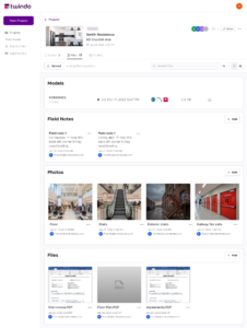
What Is a Spatial Asset?
Spatial Assets include all of your supporting documentation—CAD/BIM files, photos, notes, and PDFs—directly stored in a Twindo project. Everything you upload is available across devices, so the right information is accessible whether you’re in the field or back at the office.
Supported file types include:
- CAD/BIM: .DWG, .DXF, .SKP, .RVT, .PLN, .IFC
- 3D Models: .OBJ, .DAE
- Images: JPEG, PNG
- Documents: .DOC, .DOCX, .XLS, .XLSX, .TXT, PDF
And no, you won’t be charged for expensive hosting fees. Spatial Assets storage is included in all memberships. Learn more about memberships here.
How It Works
When you have a new asset to add to a project:
- Open the corresponding project in the Twindo iOS app or web app.
- Upload your assets for models, photos, notes, PDFs, etc. up to 100 MB each using the purple plus sign in the bottom right corner.
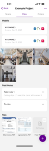
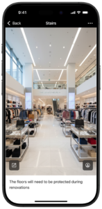
- Add titles and descriptions to each asset so context is never ambiguous.
- Browse and review your project assets anytime, on any device.
No more scattered folders. No more lost context. Just a complete project record, organized in one place.
Why Centralized Documentation Matters
Save time now, save time later
Having all of your scans, photos, field notes, and files in one place makes projects easier in the moment. Plus, it saves you time when you want to reference a model from a project your team completed three years ago.
Fewer site revisits
Whether you can’t find a site photo that you know someone took or you wrote specific measurements on a paper you can’t find, there’s nothing worse than looking for a document that you know exists. Keeping everything in one place means fewer costly return visits for details that you already documented.
Easier collaboration across teams
Your field team can capture supporting information while your office team can reference it later. Everyone on your team can access the project data they need to work efficiently. That’s the beauty of having Twindo as your one source of truth.
What’s Coming Next
Spatial Assets is just getting started. Here’s a sneak peek of what’s on the roadmap:
- Reference Measurements – Submit specific assets as reference measurements that automatically attach to the project and inform orders.
- Additional spatial intelligence reporting – Turn your spatial assets into client-ready reports you can share with customers, subcontractors, and teammates.
The Bigger Picture
Every project is more than just a single 3D model, floor plan, or collection of site photos. Spatial Assets captures everything that makes a project complete. With Twindo, you keep the full picture in one place, tied to the space where it all happened.
Ready to get to work? Start your next Twindo project.