What Spatial Intelligence Really Means and Why It’s Changing How Teams Build
Every team that works on a physical space knows the drill. You go to the site, measure everything, take photos, jot down notes, then head back to the office and try to reconstruct what you saw.
Somewhere along the way, something slips. A dimension feels off. A detail doesn’t line up. You second-guess yourself, then end up going back again just to be sure. And everyone accepts this as normal. It isn’t. It’s just the best we’ve had.
What Is Spatial Intelligence?
At its simplest, spatial intelligence is the ability to understand and work with physical space in a structured, accurate way. It turns real-world environments into something measurable, navigable, and usable by teams.
Instead of relying on fragmented inputs like photos, notes, or memory, spatial intelligence creates a shared understanding of a space that holds up across a project, from planning through execution.
At Twindo, that shows up as the ability to capture a space and carry that understanding forward in a way that stays reliable as work progresses.
“Spatial intelligence is what lets you capture a space and understand it fully without going back, without guessing, or losing the thread as files get passed between people,” says Bella Muno, Product Manager at Twindo.
What is a Spatial Intelligence Platform?
A spatial intelligence platform combines accurate capture, intelligent modeling, and shared access to give teams a reliable, up-to-date understanding of physical spaces.
Spatial intelligence platforms allow you to access physical space data and make it actionable. They can use a variety of data inputs including reality capture, 2D and 3D CAD/BIM models, and images.
But they don’t just store data—a powerful platform will layer AI analysis and make all levels of data more usable.
Eliminating the Distance Between Site and Office
Spatial intelligence closes a gap that most teams have learned to live with. The physical world and the working world are often out of sync. What happens on site doesn’t cleanly translate to what happens in the office, and that disconnect shows up in small errors, repeated work, and missed context.
“Spatial intelligence bridges that gap so what you capture in the field becomes something the entire team can actually use in the office,” Muno explains.
The result is a single source of truth. Everyone is working from the same version of the space, not their own interpretation of it.
How Twindo Delivers Spatial Intelligence
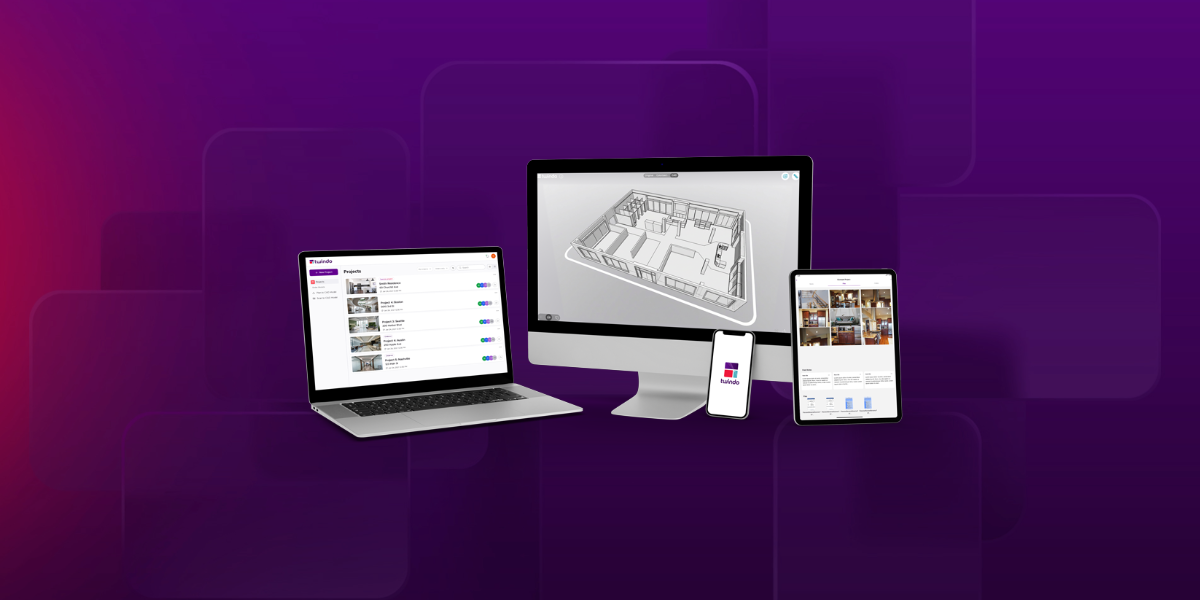
Twindo is a spatial intelligence platform built for teams that work on physical spaces and need to understand those clearly to make confident decisions.
That starts with eliminating the moments that slow teams down. Michelle Blemel, an interior designer with 25 years of experience, described the old reality well: “There’s always something you don’t measure when you’re doing it initially, and you end up having to go back to the house and re-measure. But with Twindo, everything gets captured.”
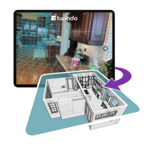
That’s the foundation Twindo is built on. A simple scan creates a digital twin of the space giving teams a design-ready 3D model with accurate measurements that everyone can work with directly.
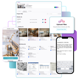
But the power of spatial intelligence is combining layers of spatial data, which is why Twindo also encompasses multiple forms of spatial assets including scans, CAD/BIM models, images, product documentation, and more.
What’s Broken in Today’s Workflow
Before spatial intelligence, documenting a space is mostly manual and fragmented from the start.
- On site: Teams measure by hand, sketch what they see, and take photos to fill in gaps later
- Back in the office: That information gets rebuilt into CAD or BIM, often from scratch, much like traditional as-built drawings.
- Time cost: Modeling can take as long as the original site visit
“It’s an incredibly time-consuming process, and it still relies on humans at every step, which means mistakes happen,” says Muno. “Teams end up spending time on work they don’t actually need to be doing.”
Even when teams try to offload that work, it creates a different kind of friction. Now you’re coordinating schedules, waiting on deliverables, and adding another layer between the site and the people making decisions.
“We hear all the time that modeling takes as long as measuring, if not longer,” Muno says. “You’re essentially translating the physical world into a digital one from scratch.”
At every stage, the process depends on memory, interpretation, and handoffs. That’s where things start to break:
- Repeated site visits
- Conflicting measurements
- Files that don’t quite match
Most teams accept it as part of the job. In reality, it’s just a workaround for not having a reliable way to capture and understand a space the first time.
What Changes When You Capture a Space
Spatial intelligence simplifies the entire workflow. Rather than collecting fragments and rebuilding later, you capture the space and carry that understanding forward. When things change, you can rescan and keep that shared model accurate over time.
On a typical job site, that means scanning the space while capturing measurements, photos, and notes in a single pass. That data becomes a structured, shared representation of the space that anyone on the project can access.
From there, teams can generate design-ready outputs like CAD or BIM models through a scan-to-CAD workflow, along with supporting assets like images, videos, and documentation. The difference is that those outputs are built from a consistent foundation, not stitched together after the fact.
The most immediate change is time. “The first thing that goes away is a huge block of time,” says Muno. “Instead of spending ten hours measuring and modeling, you can focus on client conversations, design work, or taking on more projects.”
In one project, a process that typically took 20+ hours was reduced to just 1–2 hours, giving teams a faster, more reliable starting point to work from.
There’s also a physical shift in the work itself. You’re no longer on your hands and knees double-checking measurements or trying to make sense of incomplete notes. The manual effort drops away, and the process feels more controlled.
Then there’s the perception shift. “There’s a real ‘wow’ moment when teams start using it,” Muno says. “You’re bringing technology into your process in a way that feels modern. It builds confidence with clients.”
That confidence matters. When clients see a more precise, streamlined process, they assume efficiency, accuracy, and fewer surprises, something you can see in how teams are using this in real projects.
From 2D Images to 3D Understanding
A big part of this shift comes down to context. Photos can capture details and are one part of the story, but they don’t capture relationships. You see pieces of a space, not how those pieces fit together.
“When you can actually move through a space in three dimensions, you understand how everything connects,” Muno explains.
In addition to quality images, teams can explore the space in 3D, seeing full layouts and understanding them instantly. A spatial intelligence platform’s impact comes from connecting all of the layers of data you may already have, making every element all the more valuable.
With spatial intelligence, that representation doesn’t stop at visualization. It becomes something you can actually work from. “It’s not just context,” Muno says. “It’s a file you can design from.”
That’s the point where documentation turns into something actionable.
The Role of AI (and Why It’s Not the Whole Story)
There’s a common assumption that spatial intelligence is purely automated, driven entirely by AI. In reality, accuracy matters too much for that to be the whole story. “We use AI, but we don’t rely on it blindly,” says Muno. “There are real people behind the process, verifying and refining what’s produced.”
That combination is what makes the output usable. Fully automated models can be fast, but they often fall short when precision matters. By pairing AI with human verification, the result is something teams can trust without second-guessing. The goal isn’t just speed. It’s reliability.
What This Unlocks
The real shift happens after the capture. Once a team has a reliable understanding of a space, the rest of the project starts to move differently. Instead of spending time documenting what already exists, they can focus on decisions, design, and communication. Work that used to be reactive becomes deliberate.
“Spatial intelligence is really about awareness,” Muno says. “And awareness turns into action.”
From Capture to Creation
Today, most teams capture data and then struggle to make sense of it. What’s coming next is a shift toward understanding first, and then acting on that understanding with clarity and confidence.
“Our customers are building what doesn’t exist yet,” says Muno. “The goal is to give them the tools so they can focus on that, instead of recreating what’s already there. And ultimately, that’s the goal: helping people transform spaces and improve lives.”